GEOPARD: An event-based object model
- Department SAND
- Fields involved Geomodelling
- Industries involved Natural resources
The Geopard project aims to develop a new 3D modelling tool for geologic deposits. These tools are used in natural resource evaluation, specifically to support decision making in the petroleum industry. Our objective is to build geologic principles into the programme from the beginning.
A geologic modelling tool for reservoir modelling
We have gathered a team of skilled geoscientists and statisticians, as well as petroleum industry practitioners.
The task is to develop a geologic modelling tool fit for use in reservoir modelling. All research activities in the project support this development work.

Why make a new modelling tool from scratch?
Existing tools have only a loose connection to geologic principles. This makes it difficult to transfer geologic understanding to them, and critical knowledge can be lost in the modelling process.
Rules make the difference
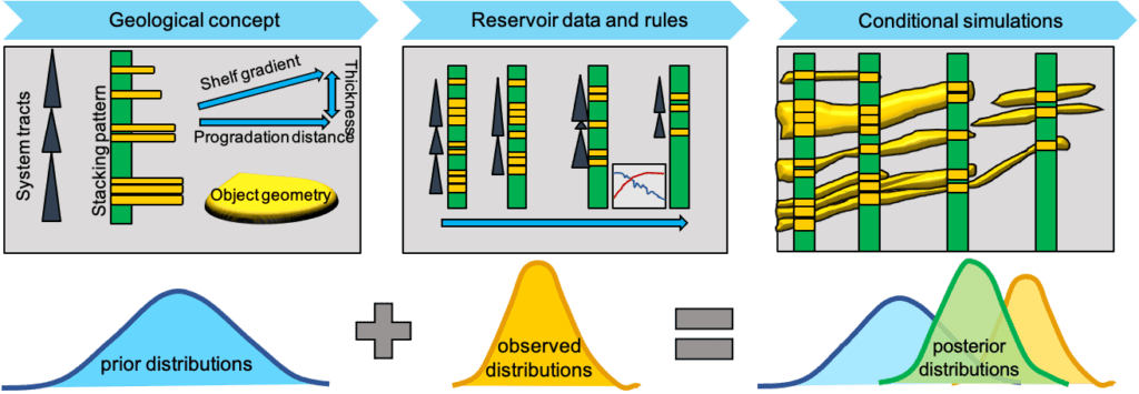
The rocks we want to model were formed by processes unfolding according to physical laws. Similar processes form similar deposits. This regularity lets us mimic the effect of actual depositional processes using simplified rules. A rule could for instance guide how sediment packages are stacked on top of each other at the mouth of a river.
The Geopard approach seeks to minimize the distance between model building and geological thinking by placing judiciously chosen geologic rules at the core of the statistical framework to be developed. Before a rule can be used in a computer programme, it must be given a mathematical formulation. We will need a set of rules that can produce geologic realism, while also being compatible with the statistical modelling framework used.

Geopard will make smarter use of available data
When searching for suitable geologic rules, we will use data from Safari. This database offers images and 3D models of outcrops of just the kind of sedimentary structures that Geopard will handle. By hewing closer to geological principles Geopard will facilitate the use of data which are already available, but difficult to use with existing tools.
A modelling approach driven by Bayesian statistics
Measurements and observations from reservoirs contain valuable information about subsurface conditions. Maintaining realism when dealing with real reservoir data is important.
Taking a Bayesian approach to statistical model specification and estimation means we can update results to conform to observations, even under large uncertainty. The Bayesian framework is the engine that will make the programme able to combine information from diverse sources and produce a realistic model. Designing and implementing software based on Bayesian statistics can be difficult. Our experience suggests it is worth it.

Navn: GEOPARD – Geostatistical event based object model predicted from analogue reservoir deposits
Partners: Equinor, Wintershall DEA, AkerBP, Vår Energi, The Norwegian University of Science and Technology (NTNU), the University of Bergen (UiB), the University of Aberdeen
Period: 2021 – 2024
Financing: The Research Council of Norway, Equinor, Wintershall DEA, AkerBP, Vår Energi
Resources
- GEOPARD – internal website (login required)
- Cristin
- Project Bank